
Arequipa Travel Guide: Is Peru’s White City Worth Visiting, and Is It Safe?
A UNESCO-listed center carved from volcanic stone, a 16th-century convent you can walk like a town, Colca Canyon, plus altitude, safety and where to stay.
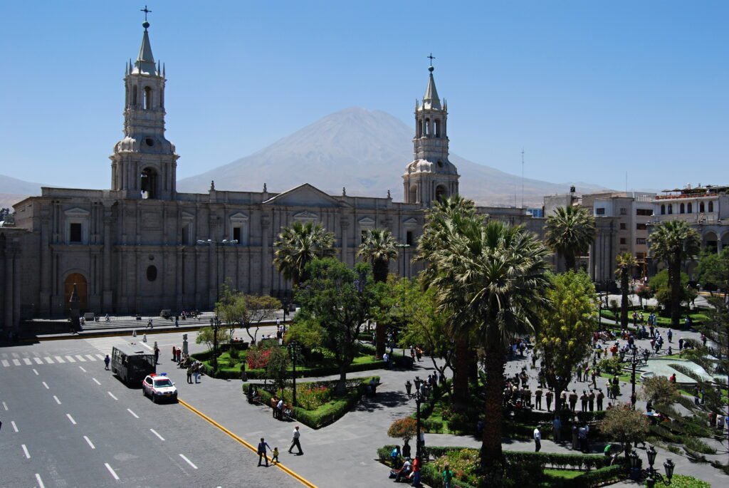
- 7,661 ft elevation
- 94 mi to Colca Canyon
- 16,109 ft at Patapampa Pass
- 3 days minimum, per PromPerú
Arequipa sits at 2,335 meters (7,661 feet) in southern Peru, beneath the El Misti and Chachani volcanoes. Founded by the Spanish in 1540, its historic center was built from sillar, a pale volcanic rock, and has been a UNESCO World Heritage Site since 2000.
Below, what the city offers, how to plan Colca Canyon, and what official sources say about safety and altitude. We drew on UNESCO, Peru’s tourism board PromPerú, France’s foreign ministry and the state news agency Andina, all checked on October 21, 2026.
Advised Traveler is free to use. If you find our content useful, you can support us by booking through our affiliate links: we earn a commission at no extra cost to you.
- Is Arequipa worth visiting?
- Top sights
- Colca Canyon
- Is Arequipa safe?
- Best time to visit
- Where to stay
- Insurance and data
- FAQ
- Sources
Is Arequipa worth visiting?
If you are heading to southern Peru, it offers three things in one stop: a UNESCO-listed colonial center, a cloistered convent that only opened to outsiders in 1970, and the gateway to Colca Canyon, up to 4,160 m (13,648 ft) deep. PromPerú suggests at least three days.
What to see in Arequipa
Plaza de Armas and the cathedral
The neoclassical square is lined on one side by the 19th-century cathedral. Its bronze fountain is topped by the “Tuturutu” figure, and on clear days you see El Misti and Chachani rising behind the rooftops. UNESCO’s listing covers about 166 hectares (410 acres) around it, prized for thick walls, vaults, courtyards and carved Baroque facades.
Santa Catalina Monastery
Founded in 1579 at Calle Santa Catalina 301, the convent stayed fully cloistered until 1970, according to PromPerú. Inside are streets, patios and cloisters laid out like a small citadel, covering more than 215,000 sq ft per Peruvian press reports. Admission is charged, but we found no current official price list, so confirm hours and fees on site or with iPerú. A guided city tour that includes Santa Catalina is one way to see it with context.
Juanita, the Ice Maiden
The Museo Santuarios Andinos at La Merced 110, run by the Catholic University of Santa María, holds Juanita, an Inca girl sacrificed more than 500 years ago on the snowcapped summit of Ampato. PromPerú lists her as on display from May to December.
Yanahuara lookout
About 1.2 miles north of downtown, this 19th-century viewpoint frames the city with El Misti behind it.
Colca Canyon from Arequipa
Plan a full day at minimum. PromPerú puts the valley 151 km (94 miles) and about 3 hours away by car; the Colca Autonomous Authority (Autocolca), quoted by the newspaper Gestión, says 4 hours on a paved road. The canyon reaches 4,160 m (13,648 ft) deep, and the Cruz del Cóndor lookout is where visitors watch condors in flight.
Altitude check: the road crosses Patapampa, the region’s highest point at 4,910 m (16,109 ft) per PromPerú. A tourist ticket is required to enter the Colca area, which Autocolca says drew about 290,000 visitors in 2024.
Our partner GetYourGuide lists Colca trips and city tours below, such as a full-day Colca Canyon round trip from Arequipa. Check the return time: France’s foreign ministry advises against driving mountain roads at night.
See all Arequipa tours and activities on GetYourGuide
Is Arequipa safe for tourists?
France’s foreign ministry, whose risk map was last revised on March 11, 2026, does not place the Arequipa region in any of its color-coded zones; those cover the VRAEM in central Peru, Abancay, Huánuco, and Lima and Callao. Americans should also read the State Department’s current advisory for Peru before booking.
- Taxis: use registered companies or ride-hailing apps rather than flagging cabs, and check the plate and driver ID.
- Buses: stick to registered bus lines; avoid informal minibuses and shared taxis, and night travel in the mountains.
- Hiking: many routes top 2,500 m (8,200 ft). Leave your itinerary with someone, carry water, food and warm layers, and go with an experienced guide.
- Strikes: protests can block tourist routes; watch for announced strikes.
When is the best time to visit Arequipa?
Mountain areas get their rainy season from January to May, according to France’s foreign ministry, with flood and landslide risk that matters for the Colca road. PromPerú lists Juanita on display from May to December. We do not publish a monthly chart because no official climate normals for the city were readable; Peru’s weather service, Senamhi, posts forecasts.
Where to stay in Arequipa
Base yourself in the historic center to walk everywhere; Yanahuara is the residential alternative north of it.
Historic center (Cercado)
Plaza de Armas, Santa Catalina and the Juanita museum within a few blocks, and an easy pickup point for Colca tours.
Yanahuara
Around the lookout and its views of El Misti. Use a registered taxi or ride-hailing app to get downtown.
See current prices and reviews for Arequipa hotels
Travel insurance and phone data for Peru
With mountain roads and a 16,000-foot pass on the way to Colca, check that your policy covers medical evacuation. Our partner SafetyWing sells Nomad Insurance Essential; confirm eligibility on its quote page. With code ADVISEDTRAVELER, first-time customers get 8 weeks of the Electronics Theft add-on free on 4-week subscription or annual Essential plans: click the pink camera on the Nomad Insurance page and enter the code before creating your account. The add-on then renews as a paid option.
Readers living in Europe can look at Chapka’s Cap Assistance 24/7. For data, compare your carrier’s international plan with a Peru eSIM from Yesim, our partner. Entry rules and the rest of the country are in our Peru travel guide.
Arequipa FAQ
How many days do you need in Arequipa?
PromPerú recommends at least three, including a day for Colca Canyon.
How high is Arequipa?
2,335 meters, or about 7,661 feet. The road to Colca climbs to 16,109 feet at Patapampa.
How far is Colca Canyon from Arequipa?
About 94 miles. PromPerú estimates 3 hours by car, Autocolca 4 hours.
Is Arequipa safe?
France’s foreign ministry does not flag the Arequipa region on its risk map. Use registered taxis or apps, avoid night travel in the mountains, and check the State Department advisory before you go.
Sources
All pages checked on October 21, 2026.
- UNESCO, Historic Centre of the City of Arequipa (in Spanish).
- PromPerú, iPerú Arequipa fact sheet (in Spanish, November 2019).
- Arequipa Regional Health Office, Arequipa district profile (elevation).
- France Diplomatie, Peru safety advice (in French, updated September 21, 2026).
- Andina, Juanita museum (November 2, 2020).
- Gestión, Colca visitor numbers for 2024 (January 1, 2025, Autocolca data).
- Infobae, Santa Catalina Monastery (August 14, 2025).
Maintained by The Advised Traveler Team. Ticket prices for Arequipa’s sights and Colca are not posted online by any official source we could read; confirm them locally or with iPerú. Spot an error? Let us know.