
Namibia Travel Guide: Visas for Americans, Self-Drive Rules, and the Best Time to Go
The visa U.S. citizens have needed since April 2025, what to know before renting a 4×4, Windhoek’s dry and rainy months, malaria in the north, and the route from Sossusvlei to Etosha.
- N$1,600 for a visa on arrival (about US$90), per Namibia’s March 2025 fee schedule
- 14.9 in of rain a year in Windhoek, almost none from May to September
- Left side of the road, with zero alcohol tolerance at the wheel
- 8,600 sq mi of savanna and salt pan in Etosha National Park
Most Namibia trips are road trips: long days on gravel between the capital, the dunes, the Atlantic coast, and the wildlife parks of the north. That makes three things worth sorting out before you book: the visa Americans now need, the rental vehicle and its insurance, and the season, which sets the heat, the rain, and the malaria risk up north.
This guide draws on Namibia’s official visa-on-arrival fact sheet, the CDC’s Namibia page, the travel advice of France’s foreign ministry (updated September 15, 2026), 1991-2020 climate normals for Windhoek, and Wikipedia for the sights. For the capital itself, see our Windhoek guide.
Advised Traveler is free to use. If you find our content useful, you can support us by booking through our affiliate links: we earn a commission at no extra cost to you.
- Visa and passport rules
- Best time to visit
- Where to go
- Driving and 4×4 rentals
- Health, malaria, and insurance
- Is Namibia safe?
- Money, time zone, and data
- Where to stay
- FAQ
- Sources
Do Americans need a visa for Namibia? Yes, since April 1, 2025
Namibia ended visa-free entry for countries that do not offer Namibians the same treatment, and the United States is on its list. Since April 1, 2025, U.S. citizens need a visa for a tourist or business visit. In a statement reported by The Namibian newspaper, the U.S. Embassy in Windhoek advised travelers to apply in advance through Namibia’s online visa-on-arrival portal and to carry a printed copy of the approval.
- Fee: N$1,600 per adult (the ministry gives about US$90), half price for children 6 to 11, free under 6, per the fact sheet dated March 31, 2025. Fees are reviewed every year.
- Online: register on the Ministry of Home Affairs e-services portal, upload a scan of your passport, pay by card, then print the e-visa for the border.
- On arrival: available at Hosea Kutako International Airport (Windhoek), Walvis Bay Airport, and major land borders such as Noordoewer, Trans-Kalahari, Katima Mulilo, and Ngoma. Smaller airports and crossings, including Windhoek’s Eros Airport, accept only the online e-visa.
- Passport: valid at least six months, with three blank pages.
The same fact sheet tells visitors to have ready a return or onward ticket, health or travel insurance covering medical costs, hotel bookings or an itinerary, and proof of funds. Families traveling with children need a full birth certificate and, where it applies, a parental consent letter, in English or with a sworn translation.
Check your entry stamp: France’s foreign ministry warns that date errors on the stamp are common, and that overstaying can lead to arrest, a court appearance, and a heavy fine. Extensions must be requested before the visa expires, at the Ministry of Home Affairs in Windhoek. For the U.S. government’s current advisory level, see the State Department’s Namibia page before you fly.
Best time to visit Namibia: the dry months from May to October
On the central plateau, rain defines the seasons. Windhoek gets 14.9 inches a year, about three quarters of it from January through March, and next to nothing from May through September. Afternoons stay warm year-round, from 70°F in June and July to 88°F in November and December, but winter nights drop to the low 40s.
- Jan 3.6 in
- Feb 3.8 in
- Mar 3.1 in
- Apr 0.8 in
- May 0.1 in
- Jun 0 in
- Jul 0 in
- Aug 0 in
- Sep 0.1 in
- Oct 0.4 in
- Nov 1.1 in
- Dec 1.9 in
Windhoek: average monthly rainfall, 1991-2020 normals for Eros Airport. Yellow: under 0.4 in. Light blue: 0.4 to 2 in. Dark blue: over 2 in.
| Month | Low / high | Rain |
|---|---|---|
| Jan | 63 / 87°F | 3.6 in |
| Feb | 62 / 84°F | 3.8 in |
| Mar | 60 / 82°F | 3.1 in |
| Apr | 55 / 79°F | 0.8 in |
| May | 49 / 74°F | 0.1 in |
| Jun | 44 / 70°F | 0 in |
| Jul | 43 / 70°F | 0 in |
| Aug | 47 / 76°F | 0 in |
| Sep | 55 / 83°F | 0.1 in |
| Oct | 59 / 87°F | 0.4 in |
| Nov | 60 / 88°F | 1.1 in |
| Dec | 62 / 88°F | 1.9 in |
About these numbers: they come from the climate table in Wikipedia’s Windhoek article, which credits the Namibia Meteorological Service and the World Meteorological Organization; we have not seen the original data file. They describe the central plateau, not the coast or the desert.
The dry months are also when malaria risk drops in the north, according to France’s foreign ministry. Along the coast, fog shapes the Namib Desert: it is the main water source for the dune wildlife, which is one reason the Namib Sand Sea is a World Heritage Site.
Where to go in Namibia: dunes, desert coast, rock art, and Etosha
Most first itineraries loop out of Windhoek: southwest to the Namib dunes, west to the Atlantic, north through Damaraland to Etosha, with the Fish River Canyon as a long detour south.
Windhoek: where most trips start
International flights land at Hosea Kutako International Airport, 28 miles east of the city, which is also where many travelers pick up their rental. Is Windhoek worth a day or two, and what is there to do? Our Windhoek guide covers the sights, the neighborhoods, and the safety basics.
Sossusvlei and Deadvlei
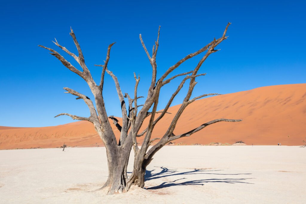
Sossusvlei is a salt and clay pan ringed by tall red dunes in Namib-Naukluft National Park, reached through the Sesriem gate. Dune 45 (about 260 feet) takes its name from its spot 45 km, or 28 miles, past Sesriem. Big Daddy, roughly 1,070 feet, towers over Deadvlei, a white clay pan dotted with dead camel thorn trees.
The paved road ends at the so-called 2×4 parking area; the last 4 miles are for four-wheel-drive vehicles only. The area belongs to the Namib Sand Sea, inscribed on the UNESCO World Heritage List in 2013.
Swakopmund, Walvis Bay, and the Skeleton Coast
Swakopmund, capital of the Erongo Region with 75,921 residents in 2023, sits 219 miles west of Windhoek on the B2. Next door, Walvis Bay has the only natural deep-water harbor on Namibia’s coast and an airport that issues visas on arrival. North of the Swakop River, the Skeleton Coast runs all the way to the Kunene River and the Angolan border.
Damaraland and the Twyfelfontein rock engravings
In the Kunene Region of the northwest, Twyfelfontein (ǀUi-ǁAis) holds one of Africa’s largest concentrations of rock engravings, a record of hunter-gatherer rituals spanning at least 2,000 years. It became Namibia’s first World Heritage Site in 2007. Distances are long out here, so carry water, spare fuel, and a second spare tire.
Etosha National Park
Set aside as a game reserve in 1907 and a national park since 1967, Etosha covers about 8,600 square miles, close to a quarter of it taken up by the Etosha salt pan. The park counts 114 mammal and 340 bird species, among them elephants, lions, and black rhinos. It lies in a malaria area; see the health section below.
Fish River Canyon and Ai-Ais
In the far south, the canyon runs about 100 miles, up to 17 miles wide and nearly 1,800 feet deep. Its multi-day hiking trail, about 56 miles from Hobas to the hot springs at Ai-Ais, usually takes five days, and permits are issued only from May to mid-September.
Dune trips at Sossusvlei, guided drives in Etosha, or boat outings from Walvis Bay: the button below opens our partner GetYourGuide’s Namibia listings. Check the pickup point before you book, since a day trip here can mean several hours on the road each way.
See all Namibia tours and activities on GetYourGuide
Driving in Namibia: gravel roads, 4×4 rentals, and the insurance fine print
Traffic drives on the left, seat belts are mandatory, and no blood alcohol at all is allowed behind the wheel; offenders usually spend a night in custody and pay a fine. France’s foreign ministry tells its own citizens to carry an International Driving Permit with their home license. Ask your rental company what it requires with a U.S. license before you land.
- Gravel speeds: the legal limit on C roads and below is 100 km/h (62 mph), but the French ministry advises staying under 80 km/h (50 mph), the cap many rental companies also set.
- After dark: avoid driving, because large animals wander onto the road.
- Tires and glass: blowouts and chipped windshields are very common; off the pavement, use a 4×4 with low beams on.
- Supplies: about 1.3 gallons of water per person, food, a first-aid kit, spare fuel, and a second spare. Gas stations can be several hundred miles apart, and cell coverage has big gaps.
Before you sign the rental contract: take every insurance option offered, including tires and glass. Most rental companies track speed with a GPS unit, and going over the limit written in the contract, sometimes lower than the legal one, voids the cover. Unpaid damage can even lead to an arrest warrant that keeps you from leaving the country.
Wild camping is banned. The diamond area of the southwest (the Sperrgebiet) between Lüderitz and Oranjemund is restricted, though Lüderitz itself is open. Drones cannot be brought in without a permit from the Namibia Civil Aviation Authority, which takes several weeks.
Health and travel insurance: malaria zones and hospitals that want payment first
The CDC recommends prescription malaria medicine for the regions of Kavango East and West, Kunene, Ohangwena, Omaheke, Omusati, Oshana, Oshikoto, Otjozondjupa, and Zambezi, which takes in Etosha and the Caprivi Strip. Windhoek has no malaria transmission. Yellow fever vaccine is not required for travelers coming directly from the United States.
Make sure you are up to date on measles (MMR). The CDC also lists hepatitis A and B and typhoid, and notes that dogs with rabies are common; rabies vaccine is usually available in most of the country if you are bitten or scratched.
Namibia’s fact sheet lists medical insurance among the documents to have on arrival, and France’s foreign ministry notes that hospitals check a patient’s ability to pay and may ask for a deposit of several thousand euros before admission. SafetyWing’s Nomad Insurance Essential lists, on its plan page as of October 16, 2026, up to US$250,000 in medical costs and US$100,000 lifetime for medical evacuation, billed every 4 weeks; pre-existing conditions, maternity, and cancer treatment are excluded, and cover in your home country is limited.
With the code ADVISEDTRAVELER, first-time SafetyWing customers get 8 weeks of the Electronics Theft add-on free on Nomad Essential 28-day subscriptions or annual plans: click the pink camera on the Nomad Insurance page and enter the code before creating your account. After 8 weeks, the add-on renews as a paid option. Readers living in Europe can also look at our partner Chapka’s Cap Assistance 24h/24, which is not open to U.S. residents.
Is Namibia safe? City crime and road risks
Namibia is politically stable, but France’s foreign ministry warns that the calm of Windhoek and Swakopmund can be misleading: bag snatching, sometimes violent, and card fraud are fairly common in the bigger towns, especially in the run-up to the holidays. Knife attacks on tourists have been reported in Windhoek’s western and northern districts.
- Use ATMs inside malls or banks, take out small amounts, and never accept help at the machine.
- Get around town by rental car or a taxi recommended by your lodging, and limit walking after dark.
- Keep nothing visible in the car and check that it actually locked: thieves use remote-key jammers.
- On the road, stop only at gas stations or police posts, and do not pick up hitchhikers.
The Angolan border is in places just a low wire fence or not marked at all, and crossing it by even a few yards can mean a fine or jail. Anti-poaching units in the Caprivi Strip parks are authorized to use their weapons: if stopped, cooperate rather than drive off.
Money, time zone, and staying connected
The currency is the Namibian dollar (N$), in use since 1993 and divided into 100 cents. Keep some cash for remote stretches, and keep your card in sight when paying at restaurants. Namibia has been on UTC+2 since September 2017, six hours ahead of New York during U.S. daylight saving time and seven hours ahead in winter.
Cell service is patchy away from the main roads, which is why the French ministry recommends a GPS or satellite phone for back-road driving. For data in towns and along highways, our partner Yesim sells travel eSIMs: confirm on its site that Namibia is covered by the plan you pick, and that your phone is unlocked and eSIM-ready.
Where to stay in Namibia: book each stop of the road trip
Because wild camping is not allowed, every night needs a booked lodge, hotel, or authorized campsite, and stops are often a few hundred miles apart: settle the route first, then book. The map opens on Windhoek; type Swakopmund, Sesriem, or Okaukuejo in its search box to move it.
Check current prices and reviews for places to stay in Namibia
Namibia travel FAQ
Do U.S. citizens need a visa for Namibia?
Yes, since April 1, 2025. Apply online through the Ministry of Home Affairs portal and print the e-visa, or buy it on arrival at Windhoek’s main airport, Walvis Bay, or a major border post. The fee was N$1,600 per adult in the March 2025 schedule.
What is the best month to visit Namibia?
May through October are nearly dry in Windhoek, and malaria risk in the north is lower then. June and July nights are cold, in the low 40s°F.
Do I need malaria pills for Namibia?
Not for Windhoek or the center and south. The CDC recommends them for the northern regions, including the Etosha area and the Zambezi Region; talk to your doctor before the trip.
Do I need a 4×4 in Namibia?
For gravel roads, France’s foreign ministry recommends one, and the last 4 miles to Sossusvlei are open only to four-wheel-drive vehicles.
What currency is used in Namibia?
The Namibian dollar (N$). Carry some cash for remote areas and use ATMs inside malls or banks.
Sources
Checked on October 16, 2026.
- Namibia Ministry of Home Affairs, Immigration, Safety and Security, visa-on-arrival fact sheet (version 3, March 31, 2025, hosted by the Namibia Investment Promotion and Development Board), and the e-services portal.
- The Namibian, US tourists must obtain visas before arriving in Namibia (March 26, 2025).
- CDC, Namibia traveler information (page last updated August 25, 2026).
- U.S. Department of State, Namibia international travel information.
- France Diplomatie (French foreign ministry), Namibia pages updated September 15, 2026, in French: entry, safety, health, practical information.
- Wikipedia: Windhoek (1991-2020 normals), Sossusvlei, Etosha National Park, Fish River Canyon, Swakopmund, Walvis Bay, Skeleton Coast, Hosea Kutako International Airport, List of World Heritage Sites in Namibia, Namibian dollar, Time in Namibia.
Researched and written by the Advised Traveler team from the sources listed, with no trip of our own behind it. Namibia reviews its visa fee every year, and national park entry fees are not listed here: confirm both with the Namibian authorities before you go. Spotted an error? Let us know.